The D'nigi Hut loop is really the only major hut traverse that has VERY little information on it! No maps, just a few simple summaries on the MCA page:
Via Moose Creek Trail: Drive east on the Glen Highway until you reach Buffalo Mine Road (mile 53). Take that road, past Murphy Road until you must park because it becomes too rough. From the end of the road continue on trail, through private property, until you reach Moose Creek where you can ford with aid of ropes stretched across the creek. The trail now trends easterly, away from the creek, often with side trails. It eventually zig-zags back to the west and north, climbing just east of a knoll. From the knoll trail drops through alders to a hunters' camp and a knee to thigh deep crossing of Moose Creek. Beyond the ford follow a poorly maintained horse trail as it follows the creek for next 8 miles. Cross Moose Creek again, leaving the trail behind and ascend a prominent, westerly flowing creek. The hut is located near the end of this drainage, if you ascend the creek on the north side, the hut might not be visible until you get quite close.
Via Eska Creek-Moose Creek Benches: Drive to Sutton on Glen Highway, turn left on Jonesville Road, follow it past a tiny community of Eska, follow dirt road used by cyclists and 4-wheelers, conditions and equipment permitting, to gain top of a ridge which leads to Knob Creek. Park before reaching the ridge top due to ruts in places. Stay on the main thoroughfare along the ridge top going east to reach Knob Creek. Just beyond look for a left turn descending north-west (61,45.578-148,52.414, 2801 feet elev.). This trail will eventually lead through brushy lowlands winding its way and gradually going up, until it eventually leads to an overlook of Eska Creek. It ends at a waterfall between Eska and Granite Peaks, 5 miles from the start of hiking. Leave the trail to follow a path east of waterfall until you are above them, cut left through the boulders to rejoin this trail into the high country. The trail follows Eska Creek before petering out and splitting. Take the north branch past some waterfalls into a hanging valley above 4400 feet. Follow the valley past a ridge which comes down from the west. At about 4455 feet (61,47.792-148,55.65) go west up easy slopes to reach small tarns and a wide bench. The objective is Elbow Pass at 5108 feet (61,48.022-148,56.749). At the pass leave behind Eska drainage and ascend 200 feet on boulders. Soon ascend to another pass to the north, crossing an east-west ridge at (61,48.088-148,57.172, 4847 feet elev.). Descend west towards Moose Creek, dropping to 3200 feet at point (61,48.582-148,59.192). You are now 5 miles from the hut. Turn north, maintaining elevation and crossing short ravines for 3 ½ miles. This bench is preferable to following Moose Creek since there is no fording or muddy trails. Begin to ascend above the bench to easier terrain as you head northeast above the deep ravine of the creek which drains from the hut. Cross the ravine high (61,51.101-148,57.553, 4009 feet elev.). The hut might be visible for a mile or so before reaching it, otherwise stick to the creek and you can't miss it.
Via Grizzly Pass: Accessing the hut requires glacier travel skills, beware of inherent risks. From Mint Hut cross the meadow to the north, ascend the easy ridge leading to Jewel Lake. Ascend scree slopes to Mint Glacier. Continue across the crevasse-free glacier to the base of Spearmint Peak. Ascend on slightly steeper ice to a bench (crevasse danger here), and work your way to Grizzly Pass (5750).Descend the ice from the pass, leaving behind the Little Susitna for Moose Creek drainage. The ice turns into moraine and boulders within 500 feet. Descend about 1300 feet from the pass to follow the summer route, winter route keeps dropping to avoid avalanches. In summer head south-southeast across boulders and tundra to get around a shoulder of a ridge coming west of the Troublemint Peak. The bench becomes very easy and gradually reaches a hanging valley below Troublemint. Cross a small creek and continue towards Moose Creek and a steep overlook of the valley below. Descend one of the scree gullies to get below the cliffs to the creek where you will reach the horse trail. Skip this trail, cross the creek and ascend 1100 feet heading east. A half a mile boulder field will cross your path, and you may not see the hut until you are rather close, nevertheless, heading east will bring you to the hut or the creek which drains from it."
It's fun to do things with a little unknown.
 Dnigi Hut
When I first made it to the Dnigi Hut, the logbook had a total of 70 entires in it, despite the logbook (and hut) being 20 years old. Tom Choate was one of the first, having made it to the D'nigi Hut on a solo trip when he was 61 years old at the time.
https://www.adn.com/alaska-news/article/anchorage-man-78-sets-record-oldest-mckinley-summiteer/2013/07/10/
I first learned about this hike in summer 2015 when the Mountaineering Club of Alaska (MCA) mentioned they were planning on closing it. There were mold issues? I definitely never saw any, despite looking hard, but it's possible it's deep within the wood foundation. Regardless, as with all hut trips, I prefer to camp outside anyway! Plus, the D'nigi Hut is in a poor location for evenly spacing distance on the loop for a long weekend trip. I went to explore with Laura Fox in Summer 2015, and loved it so much I headed back out in July 2016 with a group of friends. I had my heavy load, huge bear barrel, heavy 1970's sleeping bag from my father, and tons of water. Laura Fox definitely taught me a lot about the benefits of ultralight packing. It may cost a lot more, but to turn backpacking into a fun activity, and saving your knees is definitely worth the cost, as long as you're planning on doing it a lot. This is the traverse that really made me re-analyze my gear and change it all up.
This loop starts at either Gold Mint Trailhead in Hatcher Pass, or at Eska Falls Trailhead, and is 24 miles. 3 days is definitely required, though if you're full of energy, you can stage cars after work in late June/early July when it's still light until late, and head up to the flat area above Eska Falls.
Eska Falls Trailhead is tricky. My little Honda doesn't make it up the road, so I park in a small parking lot on the left side before the incline even begins. It's about a 1.5 to 2 mile hike to the trailhead, unless you can find a way to drive there. If you do drive there, realize there's really not much parking up top! But once you get to the actual Eska Falls Trail, you'll be amazed at how great the new trail is that Matsu Borough built, despite the lack of an easy road to get up there. Follow this trail up to the falls, where you'll likely be passed by a few ATV groups, and pick a trail on the right side going up the side of the waterfall face. Once up top, stay close to the creek, as there's a trail there that meanders through the boulder field. Stay on the right (east) side of the creek the whole way. Here is a good camping spot if you're in the mood. Otherwise, you'll keep continuing up the main valley, looping around a large knobbed mountain on the east side of the valley, and heading straight up to Elbow Pass. It's easy to tell which one is Elbow Pass...it's the only one that looks possible to climb from the valley.
Once at the top of Elbow Pass, there's a large snow patch below a steep scree face. Pick whatever route you'd prefer...if you follow the snow down, you'll have to climb up possibly a hundred feet to get back on the ridge. If you follow the scree over, it gets a little dicey, but totally doable. From the top of the ridge after the scree, you drop straight down to the northern valley.
Drop down the valley until you hit about the 3,000 foot elevation mark, where there is a ledge. Follow this ledge as best as you can until you're nearly up to D'nigi Hut. There are 6 large drainages you must go over, and these are a pain...as each one is 60+ feet deep.
Head northeast when the D'nigi Valley presents itself, and realize that the easiest way to cross the creek is all the way at the base of the rock glacier. So head in that direction. From there, you'll see the D'nigi Hut, as a tiny little white speck in the distance.
From Dnigi Hut, keep heading aiming for the top of the Moose Creek Drainage. But learning from past experience following Moose Creek: stay as high as you can! Once you get to the top of the Moose Creek Valley, you'll take a left up a ravine, nearly bypassing the Boulder Fields.
From here, it's all a game of knowing where you're going! It's a maze of trial and error on which route is best to avoid the giant Boulders. If you go early in the season, most of these boulders are covered up.
From the top of Grizzly Pass, overlooking Mint Glacier, be aware that there is a small bergshrund near the top of the Glacier. It was totally covered in snow when we did this in early July 2016, but in August 2015 it was very visible. There are no other crevasses on Mint Glacier that I've ever witnessed, but all of this can change in no time.
Dnigi Hut
D'nigi Hut
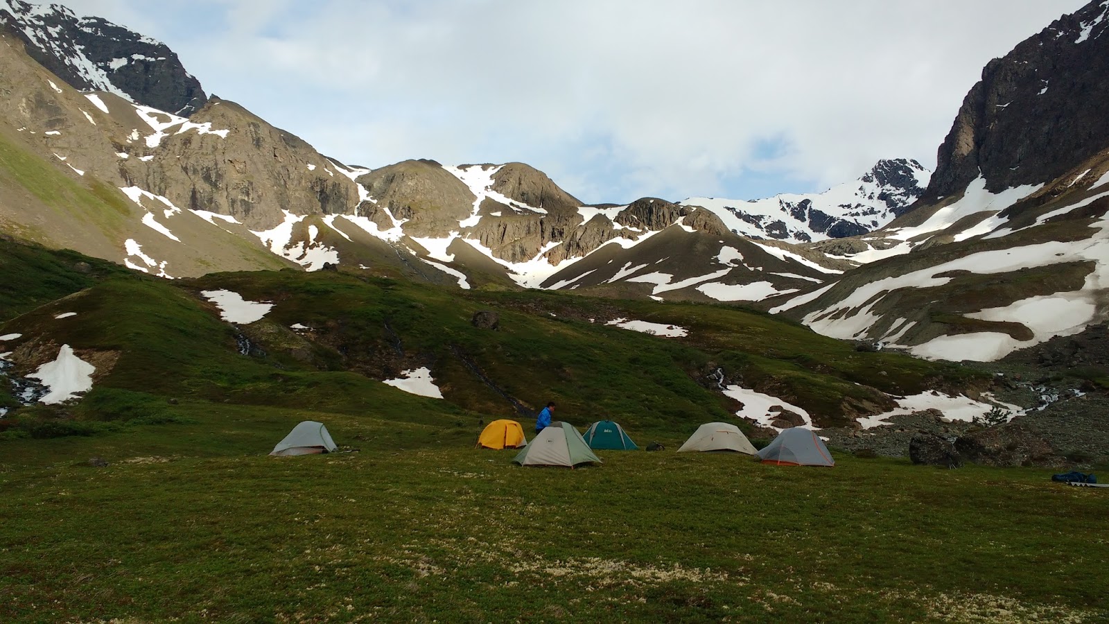
We camped out on the ledge about a thousand feet above Moose Creek, as D'nigi Hut was simply too close to Mint Hut to evenly space the trip out.
Heading up the valley to Elbow Pass